
The Track and Effects of EF-4 Tornado North Central Alabama
(Including Tuscaloosa and Birmingham)
April 27, 2011
Complete was disappointed to see the terrible damage inflicted on our neighbors to the north. We were just clearing out of Atlanta for the National Hurricane Conference when folks began deploying to North Carolina. The next thing you knew, all places throughout the Southeast were having severe weather and tornadoes.
What are tornadoes?
According to the Glossary of Meteorology (AMS 2000), a tornado is “a violently rotating column of air, pendant from a cumuliform cloud or underneath a cumuliform cloud, and often (but not always) visible as a funnel cloud.” Literally, in order for a vortex to be classified as a tornado, it must be in contact with the ground and the cloud base. Weather scientists haven’t found it so simple in practice, however, to classify and define tornadoes. For example, the difference is unclear between a strong mesocyclone (parent thunderstorm circulation) on the ground, and a large, weak tornado.
There is also disagreement as to whether separate touchdowns of the same funnel constitute separate tornadoes. It is well-known that a tornado may not have a visible funnel. Also, at what wind speed of the cloud-to-ground vortex does a tornado begin? How close must two or more different tornadic circulations become to qualify as a multiple-vortex tornado, instead of separate tornadoes? These are the questions that expert meteorologists are faced with following a massive outbreak like we have had this spring.
What is the original F-scale?
Dr. T. Theodore Fujita developed a damage scale (Fujita 1971, Fujita and Pearson 1973) for winds, including tornadoes, which was supposed to relate the degree of damage to the intensity of the wind. This scale was the result.
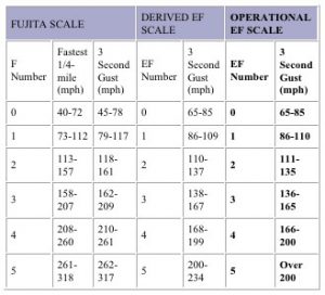
The original F-scale should not be used anymore, because it has been replaced by an enhanced version. Tornado wind speeds are still largely unknown; and the wind speeds on the original F-scale have never been scientifically tested and proven. Different winds may be needed to cause the same damage depending on how well-built a structure is, wind direction, wind duration, battering by flying debris, and a bunch of other factors.
Also, the process of rating the damage itself is largely a judgment call–quite inconsistent and arbitrary (Doswell and Burgess, 1988). Even meteorologists and engineers highly experienced in damage survey techniques often came up with different F-scale ratings for the same damage. Even with all its flaws, the original F-scale was the only widely used tornado rating method for over three decades. The enhanced F-scale took effect 1 February 2007.
What is the Enhanced F-scale?
The Enhanced F-scale (simple table or detailed 95 page PDF) is a much more precise and robust way to assess tornado damage than the original. It classifies F0-F5 damage as calibrated by engineers and meteorologists across 28 different types of damage indicators (mainly various kinds of buildings, but also a few other structures as well as trees). The idea is that a “one size fits all” approach just doesn’t work in rating tornado damage, and that a tornado scale needs to take into account the typical strengths and weaknesses of different types of construction.
This is because the same wind does different things to different kinds of structures. In the Enhanced F-scale, there will be different, customized standards for assigning any given F rating to a well built, well anchored wood-frame house compared to a garage, school, skyscraper, unanchored house, barn, factory, utility pole or other type of structure. In a real-life tornado track, these ratings can be mapped together more smoothly to make a damage analysis.
Of course, there still will be gaps and weaknesses on a track where there was little or nothing to damage, but such problems will be less common than under the original F-scale. As with the original F-scale, the enhanced version will rate the tornado as a whole based on most intense damage within the path. There are no plans to systematically re-evaluate historical tornadoes using the Enhanced F-scale. A full PDF document on the Enhanced F-scale is online and worth the read.
Meteorological Discussion and Synopsis of tornadoes 9 EF-4
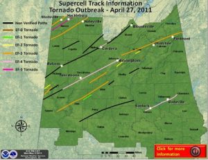
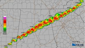
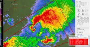
There were two waves of widespread severe weather. The first moved through during the early morning hours across northern portions of Central Alabama producing widespread damaging straight line winds and isolated tornadoes. The second wave involved numerous supercell Thunderstorms and produced long lived…strong to violent tornadoes across the northern two-thirds of central Alabama…with widespread and catastrophic damage in several locations. At this time all ratings are preliminary.
National weather service meteorologists have begun surveying the massive damage associated with this long track tornado…by ground and air. The start point is based on aerial survey…while the end location was determined by a ground crew. Thus far…detailed damage inspection has revealed a maximum of ef-4 damage in the Pleasant Grove, Al. . Casualty information is based on the latest official releases from the Alabama emergency management agency.
This tornado was produced by a supercell thunderstorm that began in Newton county Mississippi at 254 pm CDT…finally dissipating in Macon county North Carolina at approximately 1018 pm CDT. So…this supercell existed for about 7 hours and 24 minutes…traveling approximately 380 miles producing several strong to violent tornadoes along the way. Such an outbreak like the April 27 one is extremely rare and historic when it happens.
How did this Outbreak occur?
The jet stream was down south, guiding the low pressure center east with the cold front that would produce the tornadoes. The jet stream was unusually strong, and the storm system may have even gotten some of that energy from the jet stream. The jet stream made for a high wind shear event, favorable for tornadoes in some areas. Additionally, the jet stream separates warm and cold air.
With the cold front bringing the cold air from above the jet stream and the warm front bringing warm air from below the jet stream, it was a very volatile situation to start with.
EHI (Energy Helicity Index) combines wind factors (like helicity, which is a spinning motion) and energy factors (like CAPEs, which produce stronger and more volatile storms) to make a sense of what the potential is for rotating supercells. The EHI index was incredibly high for the outbreak. This is probably the biggest factor that directly contributed to the tornado outbreak.
CAPE values indicate potential energy that can be utilized by thunderstorms. The higher the CAPE, the more unstable the atmosphere. CAPE values were witnessed to be up to 4,000 j/kg, possibly even more.
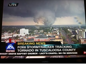
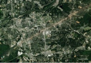
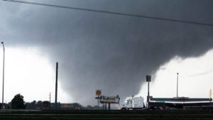
Description of tornadoes 9 and it effects as it moved over Tuscaloosa.
The south side of Tuscaloosa was heavily damaged. One tornado moved down Interstate 359 and a second tornado was spotted near Skyland Boulevard. This tornado was shown live on ABC 33/40. McFarland Mall was in the way of this tornado with debris falling from the sky.
Reports of numerous homes destroyed in the Flatwoods area of Tuscaloosa at 5:15 pm CT. Also the University Mall in Tuscaloosa, AL was destroyed by the tornado that headed towards Birmingham.
A local resident made the following report… “In my car at corner on McFarland. Milo’s Hamburgers isn’t there anymore,” Tuscaloosa resident Phil Owen told ABC News affiliate WBMA. “Hobby Lobby [is the] only thing still standing at Woods Square Shopping Center. Big Lots, Full Moon Barbecue – piles of garbage where those places were.” – Courtesy of WBMA, Birmingham, Alabama
Conclusions
The following preliminary conclusions can be stated about tornado #9 that passed over north central Alabama on April 27th:
PRELIMINARY DATA…TORNADO 9…TUSCALOOSA/BIRMINGHAM (GREENE/TUSCALOOSA/JEFFERSON COUNTIES)
EVENT DATE: APRIL 27, 2011
EVENT TYPE: EF-4
INJURIES/FATALITIES: OVER 1000 INJURIES/AT LEAST 65 FATALITIES.
EVENT START LOCATION AND TIME: 33.0297/-87.935 AT 443 PM
EVENT END LOCATION AND TIME: 33.6311/-86.7436 AT 614 PM
DAMAGE PATH LENGTH (IN MILES): APPROXIMATELY 80.3 MILES
DAMAGE WIDTH: 1.5 MILES CROSSING I-65.
NOTE: MORE DETAILS ON THIS SURVEY TO COME
Complete General Contractors, Inc. is writing this report as a service to the community to glean some of the details from the awful weather last week. This is in no way an exhaustive report nor is compiled for use in any litigation or claim or expressive of any particular location. We believed that this would be good information to share and pray for all those in the affected areas.
Please feel free to call on me at Complete, Inc or email john@teamcomplete.com if we can be of service in the review and understanding of the costs associated with your losses in these regions. We work as a general contractors in North Carolina, South Carolina and Florida only and serve as professional appraisers or construction consultants only in other states.
This report is based on current data, and subject to modifications from new information.
References:
- CIMSS Satellite Blog: [Available at: http://cimss.ssec.wisc.edu/goes/blog/archives/7910]
- NWS/Tornado FAQ: [Available at: http://www.spc.noaa.gov/faq/tornado/index.html#f-scale3]
- National Center for Atmospheric Research Mesoscale and Microscale Meteorology Division Advanced Study Program:
- Original Weather Blog: [Available at: http://originalweatherblog.blogspot.com/2011/04/extensive-damage-in-tuscaloosa-al.html]