
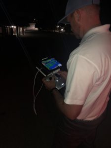
in Polk County, FL via DJI Inspire 1
and FLIR ZenMuse XT
Cutting edge building diagnostic methods out there today include thermal imaging technologies from FLIR and now drone technology, known formally as Unmanned Aircraft Systems (UAS) by the smart people at the FAA. The folks at FLIR stayed ahead of the curve by creating cameras equipped with their existing infrared capabilities but now compatible with leading drone manufacturer DJI. These cameras have the radiometric capabilities to support a full quantitative review of the image being collected. If you have a large commercial roof or roofs with suspected water damage there is no faster more economical or better way to survey the suspect damage.
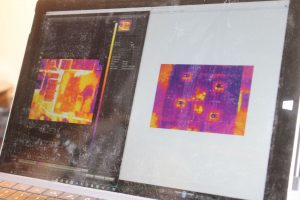
This gave the industry the ability to survey the same areas viewed from a drone during daylight again at nighttime under ideal IR viewing conditions. Finding these temperature anomalies viewed from the sky has proven a useful tool in helping us to understand roof and wall conditions. Just as important as identifying these anomalies is having the understanding of building construction and what each of these conditions indicate. Careful attention to understanding what a positive hit for elevated temperature means and does not is paramount to understanding thermal imaging technology. False positives can be ruled out with the understanding of various components of a thermal image including air conditioning, shade, and variations in insulation thickness. In addition, following thermal imaging a moisture survey using a capacitance-type meter is the next step. Following these non-destructive methods one may elect to cut the membrane as the last method of proving latent moisture in a wall or roof system. The time necessary to obtain thermal images on large commercial projects has been decreased and made safer for the thermographer. The days of climbing a roof at midnight and waiting for the sirens to go off and the police to show up are thankfully over. Regardless, there still is technique and science in the selection of weather conditions necessary for UAS operations.
The process involves two unique and involved technologies and becoming certified in each is a requirement for our surveys. Complete President John Minor became a certified thermographer more than a decade ago through the ITC (Infrared Training Center) and has been using, implementing, and understanding infrared technology since. Complete employees have attended classroom and online training through various independent training agencies and gained certification through the FAA, with more team members soon to join . For more information on becoming licensed to fly drones, visit the FAA website’s useful “Becoming a Pilot” page.
Complete looks forward to continuing to stay up to date with both UAS and drone thermal imaging technologies. We anticipate seeing guidance coming from RCI, ASTM, and the ITC as the industry jells. It is important to remember that the interest of both of these technologies is to get persons with the knowledge and understanding of building diagnostics closest to the problems at hand. These technologies are force multipliers that allow experienced inspectors to cover more ground more accurately, and safer than ever before. The age and nature of drone technology is such that the rules governing activity are sure to continue to change as laws regarding same become implemented over time. We will stay aware of these changes and we will be seeing you from the sky (with approval, of course).
Complete has grown in our fleet and our team of FAA 107 pilots. We have inspected more than 450 properties since Hurricane Michael in Bay and Gulf counties. In addition we have inspected almost 5 million s.f of school system flat roofs thermally with our FLIR advanced radiometric cameras. We have the time in the air and the night waivers to get the job done.
Thermal Imaging Drone Facts:
- A recreational pilot can fly during daylight or in twilight (30 minutes before official sunrise to 30 minutes after official sunset, local time) with appropriate anti-collision lighting. A waiver is necessary to fly at night.
- The maximum allowable altitude is 400 feet above the ground, and higher if your drone remains within 400 feet of a structure.
- A pilot cannot fly a small UAS over anyone who is not directly participating in the operation, not under a covered structure, or not inside a covered stationary vehicle.
- Operations in Class G airspace are allowed without air traffic control permission. Operations in Class B, C, D and E airspace need ATC approval.
- A pilot can request a waiver of most operational restrictions if you can show that your proposed operation can be conducted safely under a waiver. The FAA will make an online portal available to apply for such waivers.
- To operate the controls of a small UAS under Part 107, you need a remote pilot airman certificate with a small UAS rating, or be under the direct supervision of a person who holds such a certificate.
G.E. Tooling Thermal Imaging Review: Pensacola, FL
Port of Pensacola – Thermal Imaging Inspections for GE following Hurricane Ivan by Complete